GPS Map Camera
- 3.5
- Rating
- 100.00M
- Installs
- Free
- Price
 Analysis by App-foxy
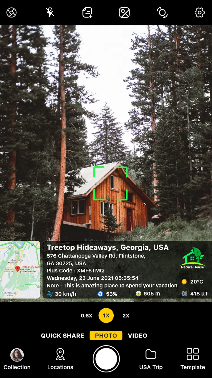
I like photo apps that solve a practical problem without asking me to rebuild my whole workflow. GPS Map Camera takes that approach by turning an ordinary phone camera into a record-keeping tool: the image can carry location details, an address, and a time stamp directly on the finished picture. That makes it more useful for documenting a job, remembering a trail, recording a property visit, or proving where a moment happened than for creating polished social-media portraits.
After using it as a photography utility, my impression is clear: this is an app for evidence and context first, artistic control second. The developer is GPS Map Camera, and the app has become a familiar choice in its category, with over 100 million installs and an average rating of 3.5 from around 376 thousand ratings. Those figures suggest a broad audience, but they also hint at a divided experience. People who need location-stamped pictures can find it genuinely handy, while anyone expecting a full replacement for a modern camera editor may find the presentation and workflow more limited.
How the current version fits into everyday photography
The current release is version 1.9.34, and it runs on Android 6.0 or later. That relatively broad compatibility matters if the app is being used on an older work phone, a spare device, or a handset issued to a field team. It is free to install, rated for Everyone, and includes optional in-app purchases priced from $2.99 to $17.99 per item. I would treat the free installation as a sensible way to test whether the overlays suit your work before spending anything.
You May Also Like

 AccuWeather: Weather Radar
AccuWeather Review: A Quick, Clear Forecast for Everyday Decisions
For everyday plans, the best forecast is the one you can understand quickly. AccuWeather makes rain timing, radar, and local conditions easy to act on, with a few trade-offs.

 Hill Climb Racing
Why Hill Climb Racing Still Turns Crashes Into One More Run
A tiny car, a bumpy hill and one more upgrade: Hill Climb Racing keeps resurfacing because its simple chaos makes every near-miss feel personal.

 AliExpress - Shopping App
AliExpress Makes Global Shopping Feel Personal, but Shoppers Bear the Risk
AliExpress turns a global marketplace into a pocket-sized discovery engine. Its reach is useful, its shopping loop compelling, and its trade-offs easy to miss.

 Lords Mobile: Kingdom Wars
Lords Mobile Is a Kingdom-Building Routine, Not a Quick Match
A case-by-case verdict on the building, battles, device demands, and social commitments that make Lords Mobile rewarding for some players and exhausting for others.

 PDF Scanner app - TapScanner
TapScanner Makes Paperwork Easier to Capture, Check, and Share
TapScanner makes scanning with a phone feel less like a rescue operation and more like a dependable step in getting work done. Its capture tools are useful, though not flawless.

 Block Blast!
 Shows How Much a Puzzle Game Can Leave Out
A quiet grid game shows why puzzle players increasingly value instant clarity, repeatable skill and low-pressure play—and where the genre still needs to catch up.
More From Our News Desk
View All News


The basic idea is simple. Instead of taking a normal picture and later trying to remember where and when it was captured, I can make the camera record that context as part of the visible image. The result is not just a photograph of a gate, road, delivery, campsite, or repair; it is a photograph that explains itself at a glance. That distinction is the reason to choose this app over the camera already installed on the phone.
In ordinary photography, a phone may keep location metadata inside the file, but that information is not always visible when the picture is shared, printed, or viewed in a basic gallery. GPS Map Camera focuses on visible context. For a person checking a folder of images later, the address and time can be easier to understand than opening a details panel or relying on memory.
I found the app most convincing when the photograph had a job to do. A contractor can capture the condition of a site before leaving. A traveler can build a visual diary without writing a separate note for every stop. Someone inspecting a rental property can connect each room or exterior detail with a time and place. A hiker can use the images as a simple trail record. These are modest tasks, but the overlay can remove a surprisingly annoying step.
A realistic workday example
Imagine arriving at a house to inspect a damaged fence. With a normal camera, I would take several pictures, then later try to match them to the address, visit time, and notes in a message or spreadsheet. With this app, I can photograph the broken section while the location and time are visible on the image. When I send the picture to a customer or colleague, the useful context travels with it rather than staying hidden in my phone.
There is an important trade-off in that scenario. The overlay improves clarity for documentation, but it also becomes part of the visual composition. If the address banner covers the exact detail being inspected, the picture is less useful. I would frame the subject with enough empty space for the stamp, take a wider establishing shot first, and then capture close-ups where the overlay does not hide the damage. That two-shot habit is more valuable than simply turning every available label on.
The same approach works for outdoor use, although I would not treat the app as a substitute for a dedicated navigation tool. A location-stamped picture can help me remember where a viewpoint, trail junction, or campsite was, but the usefulness depends on the phone obtaining an accurate position. In a dense city, indoors, or in difficult terrain, the displayed location may take time to settle. I would wait briefly before taking an important record and check that the information looks sensible.
What makes the camera different from the usual alternatives
The default camera is usually better when I care about speed, image quality, portrait effects, night photography, or a clean frame. It is already integrated with the phone, so it tends to be the least distracting choice for family pictures and spontaneous moments. A standard gallery can also show capture details later, which is enough for users who only occasionally need location information.
A map or travel app is better for planning routes and viewing places geographically, but it is not necessarily the fastest way to create a visual record of a physical condition. A note-taking app can store an address beside a picture, yet that requires discipline and a second step. GPS Map Camera sits between those tools: it puts practical metadata into the image at the moment of capture.
That focus is also its limitation. I would not choose it as my only camera for a holiday album or as a serious editing tool. The visible stamp can make a picture look busy, and the app’s value decreases when the audience does not need the location. For a clean, timeless photo, the regular camera remains the better option. For a documented visit where context matters more than presentation, this specialized approach is more efficient.
Useful habits that improve the results
My first recommendation is to decide whether the picture is for documentation or memory before pressing the shutter. If it is documentation, I would keep the location and time visible and compose around them. If it is a personal photograph that may later be shared publicly, I would think carefully about whether showing an exact address is appropriate. A visible location can reveal a home, workplace, or private meeting place, so convenience should not replace judgment.
Second, I would separate overview images from detail images. The overview establishes the place and benefits from the full stamp. The detail image should prioritize the subject, with the overlay positioned where it does not cover a crack, label, measurement, or other important evidence. This workflow gives me both context and clarity instead of trying to make one frame do everything.
Third, I would check the result immediately after taking an important picture. A visible address is useful only if it is readable and correct enough for the purpose. If the phone has just moved, the location may still be updating. Retaking the image after a short pause is far cheaper than discovering later that several pictures are associated with the wrong place or an incomplete address.
There is another less obvious consideration: stamped images are not always ideal as the original archive. For long-term organization, I prefer keeping an unstamped original when the workflow allows it, then using the contextual version for reports or messages. That preserves flexibility for later editing while still giving other people an immediately understandable record. The app is strongest as a documentation layer, not necessarily as the only copy of every photograph.
How the app has developed and what the current release means
The app was released on March 29, 2020, and the current version is 1.9.34. I see that progression as evidence of an established utility rather than a brand-new experiment. The large install base also indicates that the concept has reached far beyond a tiny specialist audience. Still, a version number alone does not tell me that every part of the experience has been transformed, so I would judge the current release by whether the core capture-and-context workflow is dependable on my device.
For existing users, the most important effect of continued development is likely practical stability: being able to open the camera, obtain location information, capture the image, and review the result without changing the purpose of the app. That consistency matters more here than flashy visual redesign. People using it for inspections or travel records need a predictable process, because a surprise in the middle of a job is more damaging than a missing decorative option.
New users should approach the current version with a focused expectation. It is not necessary to learn a complicated photography system to understand the main benefit. The real learning curve is deciding which information belongs on the image and how to compose around it. If I enable every available detail without considering the frame, the result can feel cluttered. If I choose only what the recipient needs, the stamped photo becomes much easier to scan.
The app’s age rating of Everyone also fits its straightforward purpose. That does not mean every use is automatically harmless: location information can be sensitive, and sharing a photograph with an address deserves care. The rating describes the general suitability of the app, not the privacy implications of every image a user creates. I would be especially cautious when photographing children, private homes, or places that should not be publicly identified.
Where the experience still falls short
The biggest weakness is the tension between useful information and visual clutter. A timestamp and address can make a record more credible and convenient, but they can also dominate a small phone screen or distract from the subject. This is not a flaw that can be solved by better photography technique alone; it is built into the idea of printing context onto the frame. Anyone who wants elegant, unobstructed images should skip this style of camera.
Location reliability is another practical gap. The app can display a position, but the phone still has to determine that position. Buildings, weather, crowded urban areas, and weak reception can all make location-based workflows less comfortable than taking a normal picture. I would never use a stamped address as the sole basis for a safety-critical decision. For everyday documentation, it is helpful context; for precise surveying or navigation, a dedicated professional tool is more appropriate.
The app also asks me to think about sharing. A visible address is excellent when a client needs to identify a property, but it is a poor choice for a public post that reveals where I live or where I am currently staying. Before forwarding a picture, I would inspect the stamp just as carefully as the main image. Cropping may remove the context that made the picture useful, so the better solution is often to create a separate clean copy or take a second ordinary-camera photo when privacy matters.
The average rating of 3.5 shows that the app is not universally loved, and I can understand why. A specialized tool can feel unnecessary if the phone’s own camera already records hidden location details, while users who need a polished camera may find the stamp intrusive. The broad install count should not be mistaken for a guarantee that it fits every photography style. Its success depends heavily on whether visible location context is part of the user’s actual problem.
Who should use it, and who should choose something else
I would recommend it to people who regularly need a photo to answer “where and when?” without opening another application. Field workers, property inspectors, outdoor enthusiasts, delivery teams, travelers building location-based memories, and anyone documenting progress can all benefit. It is especially practical for users who share images with people who may not have access to the original phone or its gallery details.
I would be more hesitant to recommend it to a portrait photographer, a person who mainly posts clean images, or anyone who wants advanced creative controls to be the center of the experience. The regular camera is less intrusive for those needs, and a dedicated editing app is better for color, retouching, composition, and presentation. If exact coordinates are essential, a mapping or surveying solution should take priority over a camera overlay.
The free price makes experimenting easy, but I would not pay for optional items until I had tested the complete workflow on the phone I plan to use. I would capture a few images indoors and outdoors, review the readability of the stamp, check how the pictures look after sharing, and see whether the layout works with the subjects I photograph. That small trial answers more than a feature list because the main question is not whether the app can add context; it is whether that context remains useful in my real settings.
What I would like to see next
For future development, I would watch for improvements that reduce friction without weakening the app’s central purpose. Better control over how much information appears, more flexible placement that avoids important subjects, and an even clearer distinction between documentation images and clean originals would all make the tool easier to fit into different workflows. I am describing these as sensible directions to watch, not as promises about what a later release will contain.
I would also pay attention to how the app handles the balance between quick capture and careful verification. The best version of this idea should help me create a trustworthy record without encouraging me to accept the first location reading blindly. Anything that makes the status of the displayed information easier to understand would be valuable for field use, particularly when conditions are less favorable.
For current users, the practical takeaway is to judge version 1.9.34 by the tasks that brought them here. If the visible address and time save repeated note-taking, the app remains a useful specialist camera. If those labels mostly get in the way, continued updates may not change the fact that a normal camera is a better match. The product’s evolution matters, but the core trade-off is unlikely to disappear: more context on the image means less visual simplicity.
My final view is positive but deliberately narrow. GPS Map Camera is not the camera I reach for when I want the prettiest photograph; it is the one I would choose when the photograph needs to carry its own explanation. The concept is easy to understand, the free entry point makes testing straightforward, and the current release supports a practical workflow for location-aware records. Use it when place and time are part of the evidence, not merely background information.
That distinction makes the recommendation simple. If you inspect, travel, document, or report conditions in the real world, I think it is worth trying. If you mainly want clean images, creative controls, or private sharing, keep the default camera as your main tool. Used selectively—with a pause to verify the location, thoughtful framing, and care before sharing—the app can turn a routine snapshot into a much more useful record.
FAQs for GPS Map Camera
01What is GPS Map Camera and what does it do?
GPS Map Camera is a photography app that adds location-based information to pictures while you take them. Depending on the selected template, your images can display details such as GPS coordinates, a map, address, date, time, weather, altitude, and compass direction. It is particularly useful for travel records, property inspections, construction reports, outdoor activities, and documenting where a photo was captured.
02Does GPS Map Camera require location and camera permissions?
Yes. The app needs access to your device’s camera to take photographs and location services to determine your coordinates and nearby address. Some features may also use internet access to load maps, weather data, or reverse-geocoded location details. If permissions are denied, you may still be able to use basic camera functions, but location stamps, maps, and other automatically generated information may be incomplete or unavailable.
03Can I customize the information shown on each photo?
In most versions, GPS Map Camera provides several layouts and customization options so you can choose how the stamp appears on your images. You may be able to show or hide the map, address, coordinates, date, time, altitude, weather, and other details, as well as adjust the position or appearance of the overlay. Available options can vary according to the app version and device.
04Can GPS Map Camera work without an internet connection?
The camera and GPS functions may continue working offline if your phone can obtain a location signal, but online-dependent features can be limited. Map tiles, address conversion, weather information, advertisements, and some sharing functions may require mobile data or Wi-Fi. For reliable results, open the app in advance, allow location access, and check that the required map or weather information is available before visiting an area with poor connectivity.
05Are GPS Map Camera photos accurate and safe to use as official evidence?
GPS Map Camera can provide useful visual documentation, but its information should not automatically be treated as legally certified evidence. Location accuracy depends on your phone’s GPS signal, environmental conditions, permission settings, and the time needed to obtain a position. Addresses, weather details, and timestamps may also contain errors. Review the displayed information before saving or sharing photos, especially for professional, legal, insurance, or property-related purposes.
Pros
- Adds GPS coordinates
- date
- time
- and location to photos.
- Supports map
- satellite
- and hybrid location views.
- Useful for travel records
- fieldwork
- and property documentation.
- Offers customizable photo stamps and camera layouts.
- Can save visual evidence with location details included.
Cons
- Accurate results depend on GPS signal and location permissions.
- Location data may reveal sensitive places when photos are shared.
- Some advanced templates or tools may require in-app purchases.
- Battery use can increase during extended GPS and camera sessions.
- Map features may be limited or unavailable without internet access.

GPS Map Camera
Gallery